### New Satellite to Monitor and Measure Earth’s Forests’ Carbon Storage
**Introduction to the Biomass Satellite**
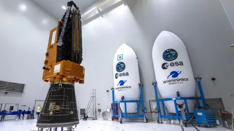
In an innovative stride towards combating climate change, a first-of-its-kind satellite is set to launch on Tuesday, capable of penetrating cloud cover and leafy canopies to assess the Earth’s forests. Named the Biomass satellite, it is developed by the European Space Agency (ESA) to “weigh” the planet’s forests, providing critical data on the carbon sequestered within trees. This information will aid in understanding how much carbon dioxide is kept out of the atmosphere, contributing to the fight against global warming.
**Importance of Carbon Measurement in Rainforests**
The forests, particularly the 1.5 trillion trees flourishing in tropical rainforests, play a crucial role in the global carbon cycle. However, calculating the amount of carbon stored by these forests has remained a daunting challenge owing to their dense canopies. Experts, led by British aerospace firm Airbus, aim to refine climate change models and track deforestation rates through the insights garnered from this satellite.
**Launch Mission Details**
Scheduled for takeoff at 10:15 BST from ESA’s Kourou spaceport in French Guiana, the Biomass satellite has affectionate nicknames like “space brolly” due to its impressive 12-meter-diameter antenna that resembles an umbrella when deployed. This antenna is designed to utilize radar technology with exceptionally long wavelengths, allowing it to see through the dense forest canopies to reveal hidden branches and trunks.
**Technological Innovations and Capabilities**
Dr. Ralph Cordey, the head of geosciences at Airbus, elaborated on the breakthrough radar technology that allows deeper penetration of forest structures compared to conventional satellite radars, which have limited capabilities in forest environments. The Biomass satellite weighs in at 1.2 tonnes and will use an approach similar to medical CT scans, capturing cross-sections of forests in a series of passes. This technique allows scientists to build comprehensive models of tree biomass, which directly correlates to the amount of carbon trapped in foliage.
**Challenges in Forest Carbon Measurement**
The existing methods for measuring forest carbon are highly manual and localized, which presents significant challenges, especially when trying to estimate the carbon in trillions of trees across vast tropical areas. Professor Mat Disney from University College London highlighted the difficulty of quantifying carbon storage in forests, noting that accurate measurements have been notoriously patchy until now. “Satellites present the only viable solution for consistent data collection at scale,” he emphasized.
As the launch date approaches, ground measurements will continue to complement satellite data in validating its effectiveness, establishing a feedback loop for continuous improvement in understanding carbon dynamics in global forests.
**Potential for Global Impact**
Despite years of preparation, the launch will undoubtedly encounter challenges, particularly the successful deployment of its large antenna, a task akin to unfurling an enormous beach umbrella in space. To ensure the technical success of this complex operation, Airbus collaborated with engineers from the American firm L3Harris Technologies, leveraging their specialized knowledge in large, deployable antennas.
If all goes according to plan, scientists anticipate generating the first comprehensive maps of forest biomass within six months of the satellite’s launch, leading into a five-year data collection period. These maps will not only illustrate carbon storage but also track losses attributed to ongoing deforestation.
**Conclusion and Future Prospects**
The Biomass satellite represents a critical advancement in environmental science, bringing unprecedented observation capabilities to the monitoring of forest ecosystems, particularly in regions plagued by cloud cover. As noted by Dr. Cordey, this mission could enlighten our understanding of how forests contribute to climate regulation and deepen our comprehension of ongoing climate changes.
Thus, the project epitomizes a collaborative effort between nations and scientific disciplines, driven by a singular mission: to sustain and protect Earth’s vital forests. Their health and growth are imperative in shaping policies to mitigate climate impact and secure a greener future.
Scientists and dedicated climate advocates continue to look forward to leverage the insights from this satellite, a potentially transformative tool in the ongoing battle against climate change.


