In a notable shift for much of the United Kingdom, cooler weather has swept across the region, marking the end of a prolonged heatwave that characterized the earlier part of July 2025. The dramatic temperature drop comes after a July that started with record-breaking heat, including the hottest day of the year recorded at 34.7 degrees Celsius (94.4 degrees Fahrenheit) in St James’s Park, located in London. While the mid-30s temperatures may have thrilled sun-seekers, the transition back to more comfortable weather conditions has been welcomed by many, especially as the forecast suggests that such heat will not return in the near future.
As the week progresses, a significant drop in temperatures of more than 10 degrees Celsius has occurred across various regions in the UK. With the shift in weather comes a yellow weather warning for heavy showers and thunderstorms issued for eastern Scotland and parts of north-east England, set to take effect on Wednesday. This emerging pattern indicates that while the sweltering conditions may have receded, they are being replaced by unsettled and unpredictable weather.
The expectation of cooler temperatures is set to last for at least the next 10 days, with brief spells of warmer weather anticipated but no forecast of another heatwave for the immediate future. Wednesday’s temperatures are predicted to oscillate between 16 and 26 degrees Celsius across the country, with a return to comfortably fresh conditions that could be seen during the night. Most of the coming week is expected to see mid to high teens in Scotland and Northern Ireland, while those in England and Wales can anticipate low to mid-20s. Interestingly, Friday could experience a brief resurgence of warmth with temperatures potentially reaching 27 or 28 degrees in the far southeast.
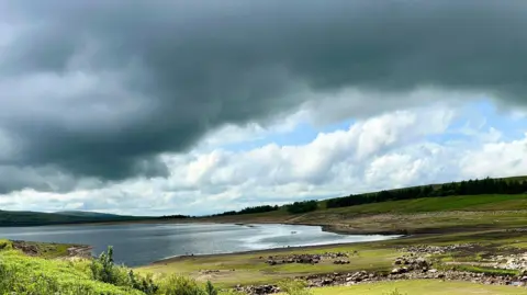
With the summer turning out to be particularly dry so far, especially in eastern England, there is anticipated rainfall in the coming days; however, this will primarily affect the north-west. Drought conditions have already taken hold in Yorkshire and parts of North-West England, with the Environment Agency noting that two-thirds of England’s rivers currently report flows below normal for this time of year. Moreover, locations in eastern Scotland and certain regions of Wales are also experiencing notably low water levels, enhancing the urgency behind precipitation forecasts.
From Thursday into Friday, rain will likely arrive, especially targeting Scotland and Northern Ireland. The weekend weather presents more unpredictability, as the UK braces for sporadic showers. Notably, the Met Office has cautioned that areas north of Edinburgh and south of Durham could be particularly susceptible to flooding due to intense rainfall, where accumulations could reach 15-20mm in less than an hour. This thunderstorm warning extends until 6 pm BST, alongside expectations of strong winds reaching approximately 40mph as the storms pass.
Reflecting on the summer, this week has marked the second heatwave of the year for the UK, a phenomenon defined by temperatures exceeding established thresholds for three consecutive days, varying from 25 to 28 degrees Celsius depending on the region. The recent heat was attributed to a high-pressure system often termed a “heat dome.” However, experts affirm that the rising temperatures across the UK should be viewed against the backdrop of climate change, which is anticipated to lead to more frequent and intense heatwaves in future seasons.
In summation, while the cooler temperatures signal a change from the heatwave, the variable weather patterns indicate that the weather will continue to evolve in the coming days. The balance between respite from heat and the challenge of unpredictable rain and potential flooding remains a topic of keen interest and concern for many across the UK as they adjust their plans according to the weather.


