In an exciting development for global science and technology collaboration, a groundbreaking satellite, known as the NASA-ISRO Synthetic Aperture Radar mission (NISAR), is on the verge of being launched. This revolutionary endeavor aims to monitor changes on Earth’s surface with exceptional precision, an advancement that could play a pivotal role in responding to natural disasters. Both the United States space agency NASA and the Indian Space Research Organization (ISRO) have joined forces for this project, which marks their inaugural partnership in launching a satellite.
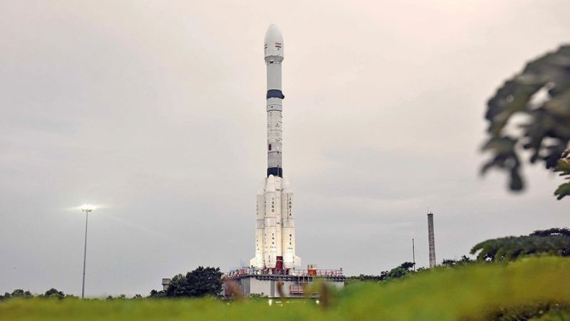
NISAR carries dual synthetic aperture radar systems, each designed by NASA and ISRO respectively. This advanced technology employs microwave signals, akin to traditional radar, but thanks to programmed data processing, it provides high-resolution imaging of the Earth’s surface. The satellite is set to take off from the Satish Dhawan Space Centre, located on the southeastern coast of India, at 8:10 a.m. ET (5:40 p.m. IST) aboard an ISRO Geosynchronous Satellite Launch Vehicle, designated GSLV-F16. Those interested in the launch can follow the event via a live stream on NASA+ along with the agency’s official YouTube channel.
Once positioned in its orbit, NISAR will make 14 revolutions around the Earth each day, allowing it to scan nearly all land and ice surfaces twice every 12 days. It has the capacity to detect surface changes down to mere fractions of an inch. This extensive data collection is anticipated to revolutionize our understanding of environmental phenomena such as landslides and earthquakes. Furthermore, it will significantly enhance monitoring capabilities for ice sheets, glaciers, forests, wetlands, and agricultural landscapes.
The NISAR mission, which was initially proposed back in 2014, represents a monumental leap in our ability to observe Earth. Nicky Fox, the associate administrator for NASA’s Science Mission Directorate, noted that the satellite will fundamentally alter how we analyze our planet, improving our ability to forecast natural events before they manifest. Minor changes to Earth’s land surface can often go unnoticed; however, these subtle alterations can have profound impacts, signifying the imperative for enhanced readiness before, during, and after natural disasters.
With a length comparable to that of a pickup truck, NISAR’s dual radar system comprises an L-band radar with a 10-inch (25-centimeter) wavelength and an S-band radar with a 4-inch (10-centimeter) wavelength. The L-band component, crafted by NASA’s Jet Propulsion Laboratory in Pasadena, California, is designed to penetrate dense foliage, while the S-band allows for more detailed observations of smaller objects. This innovative pairing of radars will facilitate comprehensive measurements of motion, land deformation, and soil moisture content.
One of the remarkable features of NISAR is its ability to function day and night in all weather conditions. By sending microwave signals to the Earth’s surface and receiving return signals via its large radar antenna, the satellite can effectively detect land movements before significant geological events, such as volcanic eruptions or earthquakes, occur. This capability alone could bolster infrastructure resilience, particularly for critical structures like levees and dams.
The inception of the NISAR mission is rooted in dialogues between NASA and ISRO that began following a 2007 report by the National Academy of Sciences. This report outlined essential research priorities focused on global observations of Earth. Subsequently, both agencies formalized their collaboration through an agreement signed on September 30, 2014.
In terms of contributions, ISRO has facilitated the S-band radar development, calibration of instruments, data processing, and algorithm creation for scientific objectives, while also providing the satellite’s body, launch vehicle, and launch services. NASA, on the other hand, has contributed a radar reflector antenna, a deployable boom, and a communication subsystem.
This partnership underscores the deeper ties being strengthened between the two nations, with both entities working closely across nearly 13 time zones. The logistics of assembling satellite components spanned two continents, culminating in India for final integration. Karen St. Germain, the director of Earth science at NASA, emphasized the collaborative nature of the project, stating, “NISAR unites the US and India to study our home planet.”
Reflecting on a broader vision, Dr. Jitendra Singh, India’s Minister for Science and Technology, remarked that NISAR represents not merely a scientific achievement, but a commitment to global cooperation. It embodies India’s aspiration to contribute significantly to the collective welfare of humanity, encompassing disaster management, agricultural monitoring, and climate monitoring.
This endeavor is indicative of how two democracies dedicated to scientific advancement and global welfare can impact not only their own nations but also provide invaluable resources and data for countries across the globe grappling with climate and disaster management challenges. NISAR is a testament to the power of international collaboration and the potential of technology to address pressing global issues.


